Aerial Market Map: Landiscor Turns Digital Images into the Standard in Market Mapping

As a collective society we love a transformative story.  Whether it is a character in our favorite movie or the narrative of an entrepreneur on a show like Shark Tank, we cannot get enough.  Simply put – something that inspires us.  We love taking something and ultimately making it better.  Companies all over the world have championed this philosophy since the dawn of industrialized thinking.  How do we take what we have here and convert it to [fill in the blank] to serve a greater need?  Businesses like Apple, Ferrari and Boeing are constantly testing how they can improve their product or process to remain on the cutting edge of innovation.  Where am I going with this?  Well I am certainly not intending to compare Landiscor to the likes of Fortune 500 companies; however, I am assimilating the shared philosophy of improved design.
Landiscor 10 Layer Market Data Model

To do this I had to start at the beginning.  When I sat back and really thought about it, what Landiscor has believed in from its very inception is the power of information – more specifically the information surrounding the change, development and growth of some of our nation’s largest metropolitan areas.  Change is necessary to reflect time, behaviors, patterns, choices… and the list goes on.  Real estate is no exception to that fact.  As we as people change so do our cities, towns and neighborhoods.  Change is sometimes met with growth.  Growth gives birth to expansion.  Here is an all too familiar example.  Jobs are introduced into an area.  New infrastructure is added to help support the local community.  New residences are developed.  Retail and shopping centers are constructed to service those new residents.  Schools, parks, amenities, etc.  This consolidated information creates an environment for faster and better decision-making while providing instant market credibility to real estate commercial brokers, land developers, builders, utilities and governments.  So, how do we keep up?

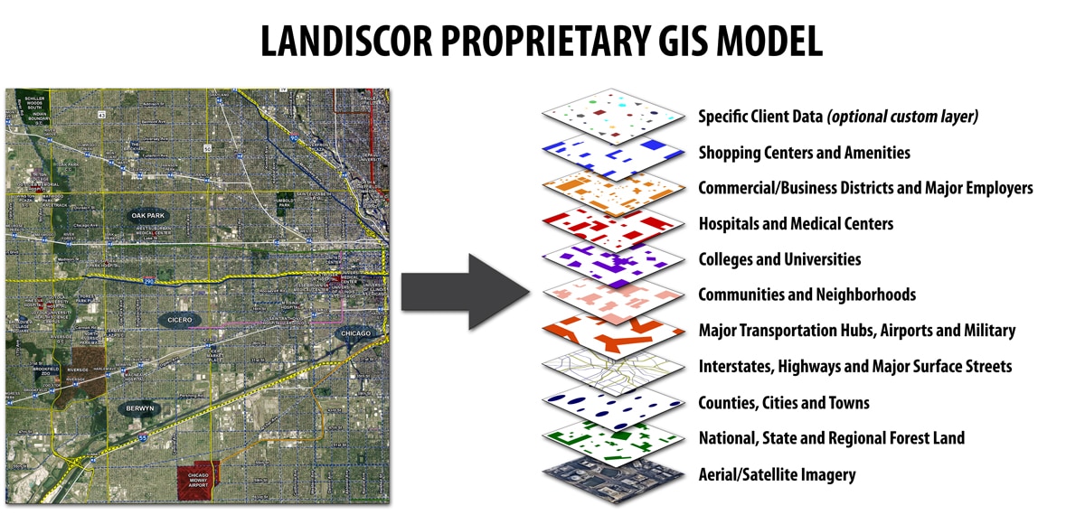
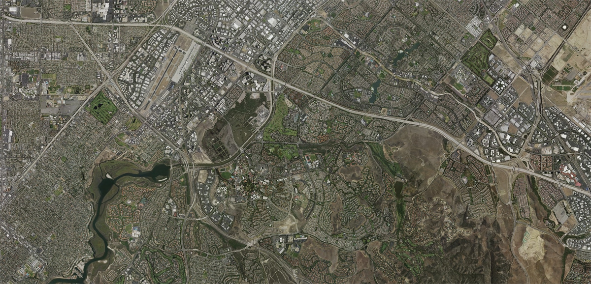
This is where Landiscor comes in.  We map the new and reoccurring development throughout a pre-defined market area.  With access to current imagery we are provided with a fresh perspective of the growth areas and change happening on the ground.  We take this raw image and combine it with information that is most vital for our customers to see and understand which we gather through a refined, in-depth research process.  The result of this is the highly unique and valued “10 Layer GIS Model” that we include on every Aerial Wall Map Mural Landiscor creates.  The goal is to provide insight to our customers about their local environment so in turn they can accurately communicate the message to their clients.  With a presence in over 25 markets, this equates to thousands of pieces of relevant information that visually shares a compelling story of change in a given area.

2015 Orange County Aerial Wall Mural Before2015 Orange County Aerial Wall Mural After

We recognize that in some cases it doesn’t end there and the client has a personal narrative to share.  Introducing the “11th Layer”.  The 11th layer consists of specific client data they wish to be digitized to the aerial map, along with our data, in order to communicate their individual footprint within the total market design.  Using the top mapping and graphic software, our production team is able to incorporate this custom data onto the map and allow the client to be part of the collective story.

Please visit our Market Data Model page to learn more.

New Nashville Aerial Map Released with Extensive Market Data

Nashville, Tennessee.  Home to the Grand Ole Opry, Vanderbilt University, the NFL’s Tennessee Titans and the NHL franchise, Nashville Predators.  As of July 2015, it is now home to a Landiscor Aerial Wall Mural.  For the metropolis nicknamed “Music City”, this news is music to the ears of real estate brokers and developers, home builders, local governments and more.  No longer will the Nashville market be perceived as overlooked or underserved.  No longer will professionals, based in Nashville, visit other cities and experience first-hand the compelling visual impact of owning a Landiscor Aerial Wall Mural, only to return home and learn that no product exists for their city.  Those days are long gone.

In a strategic decision to expand and service additional U.S. markets, the Landiscor team has adopted Nashville into its already vast market portfolio.  With over 200 identified features including communities, retail/shopping centers, major employers and more, this new aerial map is a unique blend of current imagery and vital market information with the addition of Landiscor’s proprietary aerial map GIS Market Data.  Let’s be honest.  How many times have you been in a meeting discussing current development activity and wished you had a quick and easy tool to reference?  How frustrating was it when a client would ask, “Can you show me the current growth areas and where your firm’s developments are in relation to them?” And you couldn’t.  I bet it sends shivers down your spine just thinking about it.  We are here to say, never again.

Nashville Aerial Wall Map BeforeChicago Aerial Wall Map After

With a 2015 Nashville Aerial Wall Map you will not only be able to answer these questions but will welcome them.  You will quickly transform the experience of client meetings and become an expert of your market.  Using Landiscor’s proprietary 10-layer GIS market data overlays, gain access to a full scope of valuable geospatial information that allows you to show colleagues and clients existing developments, new activity and upcoming growth across your city.  You may ask, “What if we need functional use out of the map for presentation purposes?” – 3 words.  Dry-Erase-Lamination.  With the dry erase lamination option you can interact and personalize the map for more effective visual communication.  If that’s not enough, you have the option to include a magnetic backing that allows you to use magnets on the map.
Landiscor 10 Layer Market Data Model

Think it is all too good to be true?  Find out for yourself and contact us today at 866.221.8578 or review the full Nashville aerial map now.

Chicago Aerial Map Mural Released with 700 New Market Data Points

The wait is finally over.  After 700+ data updates, a new image base layer and 3 months of research and production, the 2015 Chicago Aerial Wall Mural has been released and is ready to be prominently displayed in lobbies, conference rooms, and offices throughout Chicago.

Chicago Aerial Wall Mural

Landiscor is strategically expanding into new markets and has set its sights on the bright lights of Chicago.  In a city that has long perfected the art of patient waiting, thanks to (cough) their beloved Cubs, businesses will no longer have to wait for a mapping product that firms in the Western United States have benefited from for decades.  Why should the West have all the fun right?

Right now you may be intrigued enough to be asking yourself, what is an Aerial Wall Mural and why do we need one?  Fair question.  Imagine you are a local real estate developer and during a meeting with a potential new client they would like to see an overview of the market with your existing/planned developments plotted.  Or maybe you are a land broker that is trying to communicate the current growth trends of your market.  Perhaps you are a city government that is looking to explain the economic development opportunities to developers keen on investing within your municipality.

Look no further than Landiscor’s Aerial Wall Mural.  Our unique, large-scaled maps have been helping companies grasp the full scope of their territory and become true market experts.  We have all seen the statistic that 65% of individuals are visual learners.  Capture the attention of these individuals.  Tell them a story.  But even more than that, show them the story.  After all, would you be content with 65% of your potential business walking out the door without a true understanding of your market or your firm’s position within it?


Chicago Aerial Wall Mural Before Chicago Aerial Wall Mural After

The value of the Chicago Aerial Wall Mural is highlighted with Landiscor’s proprietary ten-layer market data model.  This unique market information is ideal for commercial brokers, real estate developers, builders, utilities and governments.  The image below overviews the application of this proprietary model that has been built over sixty years in the aerial mapping business.
Landiscor 10 Layer Market Data Model

To learn more about this new and exciting product please visit us at Chicago Aerial Wall Mural.